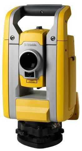
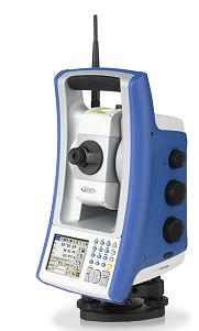
Trimble S3 Total Stations
All you need to perform efficient surveying campaigns is included in the new Trimble S3 Total Station solution: An accurate and reliable instrument, integrated robotic radio and the popular Trimble TSC2 data collector (or fixed control unit for Servo and Autolock versions) with your choice of field software, integrated high capacity battery and dual charger, and prism.
The Trimble TSC2 controller, included in this solution, is one of the most trusted and reliable data controllers and works with your choice of Trimble field software: Trimble Access, Trimble Survey Controller, or Trimble Survey Manager.
Choose Servo and Autolock with integrated control unit, or full Robotic instrument with handheld Trimble TSC2 controller
Built on proven, reliable, Trimble technology
Dependability backed by world-class training, service, and support
Foundation for Integrated Surveying
$
9,254.00
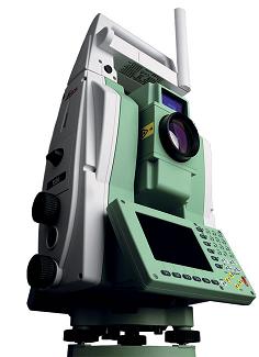
Leica TS30 Total stations
The new Leica TS30 total station is unique. This new total station has redefined precise surveying by offering unmatched accuracy and quality. Never again will surveyors with demanding tasks need to make compromises, the TS30 total station is ready for any challenge. When only 0.5” accuracy is acceptable.
Pride in accuracy
Surveyors take great pride in accuracy. The Leica TS30 delivers impressive performance in individual disciplines. But most importantly it is a champion in perfectly combining angle measurement, distance measurement, automatic target recognition and motorisation. The accuracy of the Leica TS30 is in a league of its own, a true companion for surveyors with pride.
Leica TS30 accuracy - the facts:
Angular accuracy – 0,5”
Pinpoint EDM accuracy: 0.6 mm + 1 ppm to prism / 2 mm + 2 ppm to any surface
Automatic Target Recognition (ATR) accuracy – 1"
Performance that counts
Achieving both high performance and high accuracy is challenging. The Leica TS30 has reached a new level of performance, whereby high accuracy surveying can be achieved in an easy, fast and reliable way, regardless of the project demands.
World’s best Dynamic Tracking Performance
Fastest Start-to-Finish Workflow
Long service intervals
A winning team
Leica TS30 surveyors benefit from more than a total station. What first seems to be a total station, is actually one component in the most complete portfolio of solutions for precise surveying. The Leica TS30 offers unlimited flexibility and scalability through complete compatibility with System 1200 accessories.
Automated One-Person Surveying and GNSS Extension
Setting new benchmarks in trust
It all started more than 75 years ago with the Wild T3 precision theodolite that stunned the surveying community with highly accurate measurements. Now, four generations later, Leica Geosystems continues to build on the values of accuracy and quality. The latest generation of Champions, the Leica TS30 total station has reached the pinnacle. Generations of surveyors have trusted in accuracy and quality from Leica Geosystems, now it’s time to take this trust to the next level.
Angle Measurement
The angle measurement system - for horizontal and vertical angles - is a very significant component of the Leica TS30. It must guarantee highly precise and accurate angle measurements under the high speed performance of the direct drives.
Important characteristics and advantages of the Leica TS30 angle measurement are the high measurement frequency - up to 5000 angle measurements per second - and the quadruple angle detection system.
The angle measurement accuracy of the Leica TS30 is proven and certified by Leica Geosystems’ TPM-2. This Theodolite Test Machine is part of Leica Geosystems’ calibration laboratory for length and angle. The laboratory is accredited by the Swiss Accreditation Service SAS, which belongs to the Swiss Federal Department of Economic Affairs DEA. The standard deviation (1s) of the TPM-2 angle measurements are 0.018mgon (0.058”) for horizontal angles and 0.028mgon (0.091”) for vertical angles. To test the angle measurement accuracy of the Leica TS30, the horizontal and vertical angle measurements are compared with the measurements of the TPM-2.
The standard deviation is calculated according to ISO 17123-3. For the Leica TS30, the angle measurement accuracy is 0.15mgon (0.5”).
Motorization
The motorization of the Leica TS30 uses direct drives based on the piezo principle, which directly transforms electric power into mechanical movements.
The Leica TS30 is the only total station which uses direct drives based on the piezo principle for horizontal and vertical movements of its alidade and telescope.
The direct drives using piezo technology enable high speed motorization and acceleration capabilities together with infinitesimal step sizes at low power consumption. The step sizes reach the range of nanometers. Unmatched durability and extended maintenance cycles of the direct drives are achieved by a subsequent elimination of the transmission drives moving parts. No gears are used for the movements. Furthermore, the Leica TS30 direct drives do not produce a magnetic field nor are they affected by them. This guarantees the unrestricted operation of these direct drives in magnetic fields as they can appear for instance in electric power plants.
Compared to conventional drives, the main advantages of the Leica TS30 direct drives are the following properties:
High speed (up to 200gon/s)
High acceleration (up to 400gon/s2)
Long durability and robustness
No noise emission
Compact design
No power consumption at rest
Electro-optical Distance Measurement
For the electro-optical distance measurements (EDM) on prisms, reflector tapes or natural targets, a visible laser beam, which is coaxial to the optical axis, is transmitted by Leica Geosystems’ PinPoint EDMsystem.
Leica Geosystems’ reflectorless PinPoint R1000 EDM measures to natural targets at ranges of more than 1000m. To realize these long distance measurements without any prisms or reflector tapes, Leica Geosystems’ proven System Analyzer was implemented. This procedure allows the evaluation of the total signal information for the distance determination and combines the advantages of the phase and time-of-flight measurements without having their individual disadvantages.
For the Leica TS30 total station, the Leica PinPoint EDM was improved to achieve even greater accuracy. The established PinPoint EDM enables distance measurement accuracy, on Leica round prisms (GPH1P), of 0.6mm + 1ppm (tested according to ISO 17123-4).
The PinPoint EDM provides many advantages for the distance measurements of the Leica TS30 total station. Beside the very high measurement quality and reliability, the Leica PinPoint EDM allows measurements even under adverse atmospheric conditions, such as dust, smoke, mist, rain or snowfall, etc.
Beside electronic and signal analyzing improvements of the distance measurements, the shape of the laser beam was significantly improved. This results in an optimized laser beam profile and footprint.
Cross-sectional Drawing
This picture shows a cross-sectional drawing of the Leica TS30. The drawing visualizes, in particular, the position and size of the horizontal and vertical coded glass circles.
The coded glass circles are part of the horizontal and vertical angle measurement systems. An important influence to angle measurement precision and resolution are the size of these circles. A larger diameter improves the angular precision and resolution. Therefore, the diameter of the Leica TS30 coded glass circles have been enlarged approximately 15% compared to typical 1”-total stations. The design and construction of the standards and the alidade considers the size of the enlarged coded glass circles.
$
10,590.00
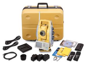
Topcon IS-3 Imaging Station
The worlds first long-range robotic scanning instrument, the IS-3
The power, accuracy, and speed of a Total Station with the auto-scanning capabilities of a Laser Scanner Topcons IS-3 takes material management, as-built design, and structural/environmental monitoring out of the clouds and puts it at your fingertips…
A new way to scan
Topcons IS-3 combines the best of two worlds, advanced imaging and high accuracy surveying, incorporating real-time field imagery with spatial data. The IS-3s powerful functionality is controlled using Topcons exclusive ImageMaster software that produces photography with dimension, a revolutionary and cost effective alternative to laser scanning.
Long Range Scanning
Nobody can provide the combination of laser scanning and robotic surveying like Topcon with the IS-3. The long non-prism (6,500 (2,000m)) robotic instrument now can scan long ranges as well. Mining and monitoring applications can be accomplished with the IS-3.
Remote Networking
The IS-3 has WLAN capability and can be controlled remotely. Imagine sitting in the comfort of your office or vehicle and being able to scan, measure, control, and see what the IS-3 is seeing.
Touch Drive Turn and select a point on screen
Simply touch the screen image to drive the cross hairs where you want. For the highest degree of data accuracy, clarity of image is key. Thats why Topcon incorporates telescopic zoom with a LCD. Using the telescope, pinpoint features to be measured or monitored precisely up to 6,500’ (2,000m) away.
Does more than a robotic instrument! Does more than a laser scanner
The Topcon IS-3 combines the power of both a laser scanner and a robotic instrument
into one superior long-range, imaging robotic system.
How it Works
Topcons IS-3 features dual digital imaging cameras providing a color, real-time image on the touch LCD display.
To define a scan area, simply tap the image display, or for uniform measurement of an area, select the grid feature. The IS-3 “locks” these points to their exact position on the image, even when the instrument is rotated.
Once all points to be measured are chosen, the IS-3 performs a reflectorless measurement of each point.
Recommended Systems
Robotic Package
Topcon IS-3
Robotic Kit
On-board TopSURV
ImageMaster IS Version
Applications: Topographic Land Surveys, Boundary Surveys, Construction Layout, Scanning from on-board TopSURV, Scanning from WiFi connected ImageMaster running on a PC.
Scanning Package
Topcon IS-3
ImageMaster Standard Version
On-board TopSURV
Applications: Long-range Scanning: quarry, mining, construction site, landfills. Mid-range Scanning: bridge, embankments, dams, levy, monitoring. Short-range Scanning: interior of buildings, lot as-builts.
The IS-3 and accessories fit into one case
Imaging Station
Carrying Case
3 Batteries BT-65Q
1 Double Charger
Tribrach
USB Cable
On-board TopSURV
ImageMaster IS
CDs Support Material
2 Carrying Straps
Sun and Rain Shields
$
13,300.00
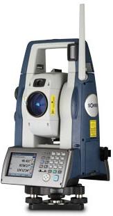
Sokkia SX Robotic Total Station
One-man measurement made simple with superior auto-tracking performance for all job conditions.
The SX robotic total station combines the latest in tracking, motorized turning, angle accuracy, and software technology providing powerful and easy-to-use “one-man” operation.
Its advanced laser measurement and image processing technologies provide extremely reliable auto-tracking capability, even in dense woods or dim conditions. Point the SX in the general direction of the prism, press the trigger key, and the SX automatically points to the prism center enabling even a beginner to rapidly take accurate measurements.
Key SX features include:
Superior Auto-Tracking Technology
On-Board Windows® CE.6.0 with Magnet™ Field
Fast and Powerful RED-Tech advanced reflectorless measurement
Long-Range Bluetooth® wireless communication
TSshield security, tracking, and remote diagnostic support
Advanced Angle Measurement System.
$
8,145.00
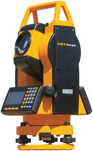
CST/Berger 305r Total station
Includes:
56-CST305R 5 Second Reflectorless Total Station
Battery Pack (2)
Battery Charger
SD Card
USB Cable
Plumb Bob
Software and Cable
Tool Kit
Operators Manual
Hard carrying case
Two Year Limited Warranty
On-Board Software - Reflectorless Range of 200M - SD Card Slot - USB Capability - Simplified User Interface
TheCST Berger Corporation introduces the NEW CST-300R Series ElectronicReflectorless Total Station— high-end features in a reliable andaffordable instrument. The
CST-300R models are easy to use and areideal for modern surveying, construction staking, mapping and GIS,geomarking, environmental studies as well as industrial
applications.
The CST/Berger Electronic Reflectorless Total Station 56-CST305R is a 5-Second Accuracy Reflectorless Total Station.
The CST/Berger introduces CST-300R Series Electronic Reflectorless Total Station offers high-end features in a reliable and affordable instrument. The CST-300R models
are easy to use and are ideal for modern surveying, construction staking, mapping and GIS, geomarking, environmental studies as well as industrial applications.
The Total Station provides precise measurement up to 9,842-ft (3000m) with a single prism and 660-ft (200m) without a prism. The 30x powered instrument has a field of
view of 1u00b030' with a minimum focus of 1.3m.
Data input is convenient too with this reflectorless total station. A dual-sided, four line LCD display is easy to read. The alpha/numeric keyboard is easy to use and
program. The CST-300R has the added feature of three on-board language choices for multi-lingual environments. Offering improved productivity, the CST-300R Series
features powerful 0n-board software in addition to the freedom of prism-less measurement.
Transfering measurements is simple with the versatility of data transfer the CST-300R Series provides. A SD card slot built into the unit is convenient for use in the
field and offers nearly unlimited storage of measurements. Data can easily be downloaded from the instrument to a computer through a USB port, RS-232 port or with a
separate card reader. With the CST-300R Series you can even transfer data wireless in the field through a PDA with a SD card slot.
The CST-300R Series Reflectorless Total Station features a water-resistant housing and are powered by an on-board battery. All the components that accompany the
instrument fit into a rugged carrying case. The CST-300R Series comes with a two year warranty.
Professional Performance At An Affordable Price
2-Second and 5-Second accuracy available
Working range up to 3000m with single prism
200m working range without prism
Designed With Durability
Superior Optics (30x Magnification)
Water-resistant housing
Proven Simplicity
Easy to target collimator
Nearly unlimited storage with built in SD card
USB and RS-232 interface
Features
Easy to target collimator
Long dual-sided graphic display and alpha/numeric keyboard
Data upload and data transfer through RS-232 data or USB port
SD card interface
Alpha / Numeric keypad
Ideal For
Surveying and Construction
Mapping and GIS
Utilities
Environment Studies
Geomarking
Archaeology
Accident Reconstruction
$
2,345.00
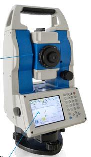
spectra precision Optical Surveying FOCUS 30
Introducing the powerful Spectra Precision® FOCUS® 30 Total Station. This fully robotic motorized solution provides improved speed, accuracy and precision in measurement. A robotic instrument moves the power of the observer from the instrument to the range pole, improving the quality of your work.
All robotic instruments include:
a motorized drive system at the instrument
a tracking sensor to track the range pole and prism
a communication connection between the instrument and range pole and prism
The speed of observation and precise positioning of the FOCUS 30 robotic total station is provided by patented StepDrive motion technology. Included in all models, the StepDrive motors control the horizontal and vertical motion, so there is no need for traditional motion locks. Using the motorized drives it is possible to precisely turn to, and repeat, angle measurements. This results in quick and reliable measurements which substantially increases your staking productivity.
The Robotic and LockNGo FOCUS 30 models include a tracking sensor that uses LockNGo tracking technology enabling the instrument to constantly lock onto the prism. The benefit of LockNGo is the ability to follow the prism at all times and reduces downtime from not having to re-point the instrument on every observation.
To maintain contact between the FOCUS 30 instrument and the remote observer with the range pole and prism, the robotic solution must include a communication link. The FOCUS 30 uses an integrated 2.4 GHz radio modem, as does the Spectra Precision Ranger™ data collector. The 2.4 GHz radio modem provides interference-free robotic data communications.
Once your robotic communications have been established you can control all the functions of the FOCUS 30 from the range pole as you move through the jobsite making measurements. This makes it possible for a single surveyor to perform high accuracy stakeout or topographic surveys by themselves. From high-order control surveys to topographic data collection or fast-paced construction stakeout, you can rely on a FOCUS 30, even in harsh outdoor conditions.
The FOCUS 30 total station is combined with Spectra Precision Survey Pro field software, providing you with world class software solutions for any surveying situation. An example of these features includes a unique robotic software technology that can be used when associating the FOCUS 30 with a low-cost GPS receiver and Survey Pro software. This combination of technologies allows the user to take full advantage of the Spectra Precision GeoLock GPS-assist technology for fast target lock. ie GeoLock helps you to quickly lock onto a target, it doesn't do anything once the target is locked on.
The Spectra Precision GeoLock technique allows a robotic total station to perform an aided search for an optical target using an initial GPS position. The remote instrument can then be directed towards the robotic roving operator using the GPS position and a subsequent search is quickly performed to re-acquire the target at the robotic rover. This technique greatly reduces wasted time, improving your field work efficiency.
The FOCUS 30 robotic solution is best described as Simply Powerful. Packaged in a modern, sleek, and streamlined design, it is easy-to-use, affordable and tough. FOCUS 30 Total Stations are designed to meet all your surveying needs.
Featured highlights
StepDrive motion technology
LockNGo™ tracking technology
Spectra Precision Survey Pro software on-board
Available in 2", 3" and 5" angle accuracies
Long-range, reflectorless distance measurement
High-precision prism measurements
GeoLock™ GPS-assist technology
$
9,382.00
Stonex positioning R2W Plus Total Station
R2WPlus, the new Stonex Windows CE based Total Station, opens a new era in the world of traditional surveying.
R2WPlus TFT 320x240 2 sides touch screen display gives the Surveyor a clear, colourful and fully graph-ical environment, and the user friendly on board soft-ware supports the users with guided through func-tions for data collection, topographic surveys, staking; many field programs are included: free station, area and volume calculations, COGO, remote elevation, missing line, and much more. The measured points are displayed on the graphical map, providing the users with a clear image of their job.
Description
The high-precision class 3 EDM featuring millimeter accuracy even on long range distances (up to 500 m reflectorless mode), and the absolute encoders per-forming angles measurements with 2” and 5”, pro-vide reliable points calculation in every condition; STONEX R2WPlus is IP55 dustproof and waterproof certified.
STONEX R2WPlus clear 30X telescope, with illumination adjustable reticle, provides superior sighting quality in any light condition.
The instrument is available 2"or 5" horizontal/vertical angles accuracy, and 2mm + 2ppm accuracy on dis-tance measurements, with a range of 500 m (reflectorless mode), and up to 3.000/7000 m with a single prism. The USB/mini USB ports, located on the side of the display/keyboard, guarantees an efficient system for data upload/download. STONEX R2WPlus is sup-plied with a built-in visible laser plummet (class 2 laser).
Key Features:
Windows CE 5.0 OS and user friendly on board software
500m reflectorless range, 2” or 5” accuracy are available.
Communication with the USB/mini USB ports to load/download data
Laser technology (class 3 laser) for long range reflectorless distance measurements
Two side high resolution TFT LCD touch screen display
Capacity Large storage capacity with 2GB internal memory
$
9,564.00
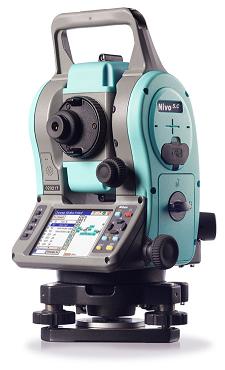
Nikon Nivo 1.C 1" Reflectorless Total Station
Survey Pro software onboard
Windows CE touch-screen
High quality Nikon optics
1", 2", 3" and 5" angle accuracies
Prism and reflectorless measurements
Easy-to-use 2nd face keypad
Hot swappable batteries
Compact, rugged, and lightweight
Cable-free Bluetooth®
Optional laser plummet
Nikon's next generation total station is the Nivo™ Total Station, available in two exciting lines: the Nivo C Series and Nivo M Series. Both of the Nivo series are the absolute leaders for go anywhere measurement tools. Compact in size and lightweight, they are convenient to carry over long distances. All Nivo models are supported with legendary Nikon high clarity optics, allowing clearer images in bright and low light conditions, making measurements easy and reducing eye stress.
The fast, long range EDM measures in both prism and reflectorless modes. Measure precisely to objects up to 500 m away without the need for a prism*. Nivo models come standard with a traditional optical plummet which can be upgraded to a laser plummet. All models include a lumi guide for stakeout assistance.
The Nivo C Series is designed with a feature-packed Windows® CE touch-screen interface. Field application software functions are supported by the world class Spectra Precision® Survey Pro™ field software for all your surveying and construction measurement needs.
All Nivo C Series solutions are designed with high productivity in mind, including a dual face display for efficient high precision angle and distance measurements. Work all day long with endless power using hot swappable batteries, you'll never need to worry about interrupting your workflow to change a battery again.
To assist you with the multitude of data needs of the 21st century, the Nivo C Series includes:
Support for USB memory sticks
Wireless cable-free Bluetooth connections to external data collectors
USB High-speed data transfer port
The Nivo C Series is available in 1", 2", 3" and 5" models to meet your specific accuracy needs.
NIKON NIVO 2.C US$6,997
Nikon NIVO 3.C US$5,997
Nikon NIVO 5C US$5,497
$
7,890.00
