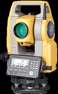
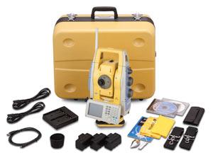
Topcon ES Series Total Station
The new ES Series was designed from the ground up to deliver the very latest technology advantages, all in a small, sleek design – you’ll appreciate the advantages from the very first measurement.
Featuring a class leading EDM unit, the ES is able to measure up to 4,000m to standard prisms, and can measure in reflectorless mode up to 500m at an incredible 3mm + 2ppm accuracy.
Measurements are carried out faster than ever, and at 15mm (over 30m), the bright red laser dot pinpoints features with ease.
Ultra-Powerful, Advanced EDM
500m non-prism range
4000m prism range
Less than 1 second fine measurement
The exclusive LongLink communications functionality in every ES Series
model provides operational capabilities never before offered in a manual total
station. With a 300m range wireless communication using Bluetooth Class
1 technology, you can now operate the data collector from the “smart-spot”
of the crew, the prism pole. Also referred to the two-man, economical robot
solution, Topcon’s new LongLink technology brings a whole new level of
flexibility to your manual field crew.
dvanced Angle Encoder System
Best in Class 1 angle accuracy available
Incorporates exclusive IACS (Intelligent Automatic Calibration System) on 1 & 2 models
Ultimate in Rechargeable operation - 36 Hours!
Up to 36 hours of operation on a single charge.*1
Eliminates the need for nightly recharging and carrying extra batteries.
Work with confidence all day without the worry of dead batteries.
Rugged, Waterproof Design
Waterproof/Dustproof IP66 design handles the toughest environments
Magnesium-alloy housing providing stable angle accuracy Completely
Easy Access USB 2.0 Memory
Up to 8MB storage
Environmentally protected
Compatible with industry standard accessories and cables
Spectification:
Angle Measurement
Min. Resolution/Accuracy
ES-101 0.5”/1”
ES-102 1”/2”
ES-103 1”/3”
ES-105 1”/5”
ES-107 1”/7”
IACS (Independent Angle Calibration System) Standard om 1 & 2 models
Compensation Dual-axis compensator
Distance Measurement
Prism EDM Range 4000m (ES-107 3000m)
Prism EDM Accuracy 2mm+2ppm
Non-Prism Range 500m
Non-Prism Accuracy 3mm+2ppm (0.3-200m)
Measuring Time Fine: 0.9 sec
Rapid: 0.7 sec
Tracking: 0.3 sec
Communications
LongLink™ rover communications utilizing Class 1 Bluetooth
USB 2.0 Slot
RS-232C Serial
General
Display/Keyboard Dual, Graphic, Backlit
LCD (ES-107 Single)
Battery Operation up to 36 hours
Dust/Water Protection IP66
Wireless Connection Bluetooth Class 1
Operating Range
-20C to +50C
-30C to +50C
-20C to +60C
$
3,690.00
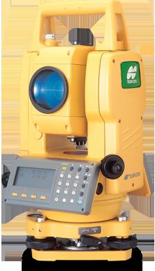
Topcon GTS-250 Series
Unmatched value, performance and quality!
The GTS-250 series combines Topcon's tradition of rugged field-ready quality and accuracy and places it in an economical, compact design perfect for everyday measuring and positioning applications.
Meeting or exceeding the precision and durability of most competitive high end models, Topcon's GTS-250 provides construction professionals and surveyors performing construction layout with a dedicated solution. The on-board software makes it easy to rapidly shoot points for quick adjustments or resets. For more advanced layout tasks use your GTS-250 with any of Topcon's field controllers running MAGNET™ software.
Economical, value priced measuring solution
Rugged, durable, water resistant design (IP54)
Two accuracies from which to choose: 2" and 5"
Dual-axis compensation
Onboard programs and 24,000 point data storage
Ideal as a construction stakeout total station
Specifications
Telescope
Length 150 Millimeters
Objective Lens Diameter 45mm (EDM:50mm)
Magnification 30x
Image Erect
Field of View 1°30
Resolve Power 3 "
Min. Focus Distance 1.3 meters
Measurement Range
1 Prism 6560 ft, 2000 meters
3 Prism 8856 ft, 2700 meters
Measuring Accuracy
Prism Mode ±(2mm + 2ppm x D)m.s.e. fine, N/A
Measurement Time 1mm: 1.2sec. (Initial 4sec.) fine, 0.2sec. (Initial 3sec.) coarse, N/A
Angle Measurement
Method Absolute Reading
Detection 2 horizontal, 1 vertical
Minimum reading 5”/1”, 1/5 mgon
Tilt Correction
Type Automatic Vertical and Horizontal compensator
Method Liquid surface reflective profile sensor reading type
Compensating Range ±3'
Correction Unit 1 arc sec, N/A
Computer Unit
Display 2 screen, dot matrix graphic LCD display
Power
Approximate battery life 9 hours including distance measurement , 40 Angle measurement only
Durability
Protection against water and dust IP54
Temperature -20 to 50 degrees C (-4 to 122 degree F)
Weight Instrument 4.9KG (10.8lb)
$
3,900.00
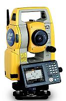
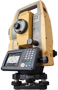
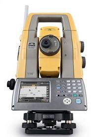
Topcon OS Series total stations
Topcons new OS Series Total Stations – New Advanced Design with Superior Technology
The OS is a professional grade compact design total station. This all new advanced design provides an on-board data collection interface, exclusive LongLinkTM communication, and an incredibly powerful EDM.
Work directly on the bright, color touchscreen, or with the alpha-numeric keyboard to achieve higher levels of production with MAGNET Field on-board software.
Features
Advanced Security & Maintenance with New TSshield™
MAGNET Field On-board
Exclusive LongLink Communications Functionality
Fast and Powerful EDM
Advanced Angle Accuracy
The OS is the perfect total station for many field applications including:
Land Surveying Property
Land Surveying Topo & Stakeout
Earthwork Volumes
Building Interior Layout
Construction of Roads
Law Enforcement Mapping
Primary OS features include:
Exclusive LongLinkTM Ultra-Powerful, Advanced EDM
300m+ Wireless Link to Controller
Field Controller at the Prism Pole
More accurate code descriptions
Collect point Images at the measurement point.
500m non-prism range
4000m prism range
Red/Green Guidelight
Coaxial red laser pointer
Pinpoint, precise beamspot
Advanced Angle Encoder System EDM Trigger Key
Best in Class 1 angle accuracy available
Incorporates exclusive IACS
(Independent Angle Calibration System)
on 1 & 2 models
Self calibration
Proven High Accuracy Technology
Perfect touch location
Promotes angle stability
No torque when measuring on-board
Water/Dust proof
Easy for gloved hands
Advanced OS features include: Standard OS package includes:
Large Graphics
Easy to Read
Color Touchscreen
Achieve higher levels of production with MAGNET Field on-board software
Part of the MAGNET Solution, MAGNET Field On-board runs directly on the OS total station touch screen. Utilize the on-board USB port to plug a USB flash drive into the side panel for fast file transfer. Or for more traditional transfer, use a USB mini cable and transfer files to MAGNET Office Tools.
With direct exchange between MAGNET Field On-board and MAGNET Office Tools, you will see an increase in overall productivity.
All of the total station functions are available directly on-board. In Survey, there is Topo, X-Section, Find Station, Tape Dimension, and Missing Line. In Stake, there is Points, Lines, Offsets, Surface, Point in Direction, Curve, Real-Time Roads, Road, Slope, and Linework staking. Plus many calculation functions like Inverse, Intersection, Curves, Area, Corner Angle, Offsets, Adjust, Traverse, and DTM.
Alphanumeric Keyboard
4-Way Navigation Button
OS Total Station
Battery and Charger (one battery and charger included)
Lens Cap and Hood
Tool Kit
USB stick with digital Manual
Quick Guide
Carry Case and Carry Straps
QUICK Specs
Angle Measurement
Min. Resolution/Accuracy
OS-101 0.5”/1”
OS-102 1”/2”
OS-103 1”/3”
OS-105 (Single Display) 1”/5”
IACS (Independent Angle Calibration System) Standard on 1” & 2” models
Compensation Dual-axis compensator
Distance Measurement
Prism EDM Range 4000m
Prism EDM Accuracy 2mm+2ppm
Non-Prism Range 500m
Non-Prism Accuracy 3mm+2ppm (0.3-200m)
Measuring Time Fine: 0.9 sec
Rapid: 0.7 sec
Tracking: 0.3 sec
Communications
LongLink™ rover communications utilizing
Bluetooth® Class 1
USB 2.0 Slot (Host + Slave)
RS-232C Serial
General
Display/Keyboard Dual, LCD, Touchscreen
(OS-105 Single)
Battery Operation Up to 20 hours
Dust/Water Protection IP65
Wireless Connection Bluetooth Class 1
Operating Range -30C to +60C
-35C to +60C
$
5,233.00
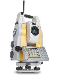
Topcon IS Imaging Station
Topcon's IS combines the best of two worlds, advanced imaging and high-accuracy surveying, incorporating real-time field imagery with spatial data. The IS's powerful functionality is controlled using Topcon's exclusive ImageMaster software that produces "photography with dimension", a revolutionary and cost effective alternative to laser scanning. Reality captured for results unimaginable.
Imaging Station Series Features:
Photo Fieldbook - creates a 360° Photo Fieldbook. In seconds.
IntelligentScan automatically recognizes significant features in the images. Its 20 pps scan rate is ideal for most applications, and its 2000m precision reflectorless range is tops in its class.
ImageDrive lets you visually operate from the controller and easily switch from imaging to prism tracking.
First with Independent Control to allow complete control from your computer, WiFi-equipped FC-2200, and other compatible devices.
Integrated dual-camera array with wide-area and 30x scope view so you can zoom in on the detail you need.
The IS doesnt forsake its robotic roots. The IS has all the features of our GPT-9000A robotic total station and more.
Our 9000A series robotic system features sophisticated technology unique to Topcon– our one-touch quick lock feature that set the standard in robotic target acquisition has taken another step forward, with the sleek new RC-3 system. All 9000A series robotic systems offer reflectorless measurement superior to any other instrument available – capable of precision measurements at a mind-boggling 2000 meters! Packed with a wide variety of advanced technologies, the Topcon GPT-9000A series robotic total station demonstrates why Topcon continues to be the world's leader in precision survey instrumentation:
Innovative, completely cable-free system design
Superior X-TRAC Quick-Lock tracking technology
Full-color, graphical Windows Mobile instrument & field controller interface
The most advanced, longest range, and most powerful reflectorless technology available
Integrated interference free 2.4 GHz SpSp robotic data communications
The X-TRAC 7 robotic system upgrade is now available for the IS instrument. This enhancement to firmware and software affects the robotic tracking, quick-lock, radios, and data collector performance.
Specifications
Angle Measurement
Method Absolute Reading
Minimum Reading 1"/5" | (0.1/0.5mgon)
Accuracy 1", 3" | (0.3mgon)
Tilt Correction Dual Axis
Compensating Range ±6'
Distance Measurement
1 prism 3,000m
3 prism 4,000m
9 prism 5,000m
Non-Prism Mode 1.5m - 250m
Non-Prism Long Mode 5.0m - 2,000m
Measuring Accuracy
Prism Fine 0.2mm / 1mm ±(2mm+2ppmxD*) m.s.e.
Non-Prism Fine 0.2mm / 1mm ±(5mm) m.s.e.
NP Long Mode Fine 1mm ±(10mm+10ppmxD*) m.s.e.
Imaging
Cameras (2) 1.3mp
Image speed 1 - 10fps
Scanning Max 20 pts/sec
User Interface
OS Microsoft Windows CE.NET 4.2
Processor Intel PXA255 400Mhz
Screen Full Color Touch-screen
$
14,300.00
Topcon IS-3 Imaging Station
The worlds first long-range robotic scanning instrument, the IS-3
The power, accuracy, and speed of a Total Station with the auto-scanning capabilities of a Laser Scanner Topcons IS-3 takes material management, as-built design, and structural/environmental monitoring out of the clouds and puts it at your fingertips…
A new way to scan
Topcons IS-3 combines the best of two worlds, advanced imaging and high accuracy surveying, incorporating real-time field imagery with spatial data. The IS-3s powerful functionality is controlled using Topcons exclusive ImageMaster software that produces photography with dimension, a revolutionary and cost effective alternative to laser scanning.
Long Range Scanning
Nobody can provide the combination of laser scanning and robotic surveying like Topcon with the IS-3. The long non-prism (6,500 (2,000m)) robotic instrument now can scan long ranges as well. Mining and monitoring applications can be accomplished with the IS-3.
Remote Networking
The IS-3 has WLAN capability and can be controlled remotely. Imagine sitting in the comfort of your office or vehicle and being able to scan, measure, control, and see what the IS-3 is seeing.
Touch Drive Turn and select a point on screen
Simply touch the screen image to drive the cross hairs where you want. For the highest degree of data accuracy, clarity of image is key. Thats why Topcon incorporates telescopic zoom with a LCD. Using the telescope, pinpoint features to be measured or monitored precisely up to 6,500’ (2,000m) away.
Does more than a robotic instrument! Does more than a laser scanner
The Topcon IS-3 combines the power of both a laser scanner and a robotic instrument
into one superior long-range, imaging robotic system.
How it Works
Topcons IS-3 features dual digital imaging cameras providing a color, real-time image on the touch LCD display.
To define a scan area, simply tap the image display, or for uniform measurement of an area, select the grid feature. The IS-3 “locks” these points to their exact position on the image, even when the instrument is rotated.
Once all points to be measured are chosen, the IS-3 performs a reflectorless measurement of each point.
Recommended Systems
Robotic Package
Topcon IS-3
Robotic Kit
On-board TopSURV
ImageMaster IS Version
Applications: Topographic Land Surveys, Boundary Surveys, Construction Layout, Scanning from on-board TopSURV, Scanning from WiFi connected ImageMaster running on a PC.
Scanning Package
Topcon IS-3
ImageMaster Standard Version
On-board TopSURV
Applications: Long-range Scanning: quarry, mining, construction site, landfills. Mid-range Scanning: bridge, embankments, dams, levy, monitoring. Short-range Scanning: interior of buildings, lot as-builts.
The IS-3 and accessories fit into one case
Imaging Station
Carrying Case
3 Batteries BT-65Q
1 Double Charger
Tribrach
USB Cable
On-board TopSURV
ImageMaster IS
CDs Support Material
2 Carrying Straps
Sun and Rain Shields
$
13,300.00
Topcon DS Series
Featuring Topcon's new XPointing technology, the DS seeks out prisms even in dim or dark conditions, fast! Tailor made for construction, the DS also features advanced TOPO, stakeout and mesh scan capabilities via it's onboard MAGNET™ software. And it's made to go right to work. In fact, the DS's ease of operation will be obvious from the time you turn it on. Simply add a data collector and the DS becomes a one-man measuring solution! The DS features a Bluetooth range of up to 1000' (300m), a waterproof housing, super-accurate encoder for reliable accuracy, and TS Shield to secure and maintain your investment. The DS is the construction layout tool you can't afford not to have.
Features:
Xpointing fast, reliable prism acquisition technology
MAGNET Software On-board
1,000m reflectorless operation
Exclusive LongLink Communications
TSshield‚ Advanced Security and Maintenance
Rugged Water Resistant IP65 construction
SPECIFICATIONS
Model DS-101AC DS-103AC DS-105AC
Telescope
Magnification / Resolving power 30x / 2.5"
Length: 168mm (6.6in.), Objective aperture: 45mm (1.8in.) (50mm (2.0in.) for EDM), Image: Erect, Field of view: 1°30' (26m/1,000m), Minimum focus: 1.3m (4.3ft.), Reticle illumination: 5 brightness levels
Angle measurement
Display resolutions 0.5" / 1"
(0.0001 / 0.0002gon, 0.002 / 0.005mil) 1" / 5"
(0.0002 / 0.001gon, 0.005 / 0.02mil)
Accuracy (ISO 17123-3:2001) 1" 3" 5"
Dual-axis compensator / Collimation compensation Dual-axis liquid tilt sensor, working range: ±6' / Collimation compensation available
Distance measurement
Laser output*1 Reflectorless mode: Class 3R / Prism/sheet mode: Class 1
Measuring range
(under average conditions*2) Reflectorless*3 0.3 to 800m (2,620ft) / Under good conditions*5: to 1,000m (3,280ft.)
Reflective sheet*4 RS90N-K: 1.3 to 500m (4.3 to 1,640ft.), RS50N-K: 1.3 to 300m (4.3 to 980ft.), RS10N-K: 1.3 to 100m (4.3 to 320ft.)
Mini prisms 1.3 to 500m (1,640ft.)
One prism 1.3 to 5,000m (4.3 to 16,400ft) / Under good conditions*5: 6,000m (16,680ft.)
Three prism to 8,000m (26,240ft.) / Under good conditions*5: to 10,000m (32,800ft.)
Display resolution Fine: 0.0001 / 0.001m (0.001 / 0.01ft., 1/16 / 1/8in.) / Rapid: 0.001m / 0.01ft. / 1/8in. Tracking: 0.01m / 0.1ft. / 1/2in.
Accuracy*2
(ISO 17123-4:2001)
(D=measuring distance in mm) Reflectorless*3 (2 + 2ppm x D) mm*6
Reflective sheet*4 (2 + 2ppm x D) mm
AP/CP prism (1.5 + 2ppm x D) mm
Measuring time*7 Fine: 0.9s (initial 1.5s), Rapid: 0.6s (initial 1.3s), Tracking: 0.3s (initial 1.3s)
Motor drive system
Type DC Servo motor
Max Rotation speed 70°/sec
Auto-Collimating
Working range*2 One prism*8 1.3 to 1,000m
Reflective sheet*9 5 to 50m
360 °prism*10 2 to 600m
Mini prisms*11 1.3 to 600m
OS, Interface and Data management
Operating system / Application Microsoft Windows CE 6.0 / MAGNET FIELD
Display / Keyboard 3.5inch, Semi-transmissive TFT QVGA color LCD with LED backlight, Touch screen, Automatic brightness control / 26 keys with backlight
Control panel location*12 On both faces (Face 2 is only touch screen display On one faces
Trigger key On right instrument support
Data storage Internal memory 500MB internal memory
Plug-in memory device USB flash memory (max. 8GB)
Interface Serial RS-232C, USB2.0 (Type A / miniB)
Bluetooth modem (option)*13 Bluetooth Class 1, Ver.2.1+EDR, Operating range: up to 300m (980ft.)*14
General
Laser-pointer15 Coaxial red laser using EDM beam
Guide light15 Green LED (524nm) and Red LED (626nm), Operating range: 1.3 to 150m (4.3 to 490ft.)
Levels Graphic 6’ (Inner Circle)
Circular level 10' / 2mm
Optical plummet Magnification: 3x, Minimum focus: 0.3m (11.8in.) from tribrach bottom
Laser plummet (option) Red laser diode (635nm±10nm), Beam accuracy: <[email protected], Class 2 laser product
Dust and water protection IP65 (IEC 60529:2001)
Operating temperature -20 to +50ºC (-4 to +122ºF)
Size with handle*9 Control panel on both faces:
W207 (W) X 190 (D) X 372 (H) mm (W8.1 x D7.5 x H14.6in.) Control panel on one face:
W207 (W) X 174 (D) X 372 (H) mm (W8.1 x D6.8 x H14.6in.)
Weight with battery & tribrach Approx. 6.1kg (13.4lb.)
Power supply
Battery BDC70 detachable battery Li-ion rechargeable battery
Operating time (20ºC) BDC70 Approx.5hours (Fine distance measurement (single) using Auto-Collimating, repeated every 30 seconds)
External battery (option) BT-73Q: approx. 14.5hours (Fine distance measurement (single) using Auto-Collimating, repeated every 30 seconds)
$
5,165.00
Topcon MS, 0.5 Measuring Station
Featuring a wide array of innovative technologies, the MS05A total station offers superior performance in angle and distance measurement as well as reliable robotic functionality. The ‘Measuring Station’ ensures dramatic enhancement in precision and productivity in all applications such as surveying, engineering, construction, monitoring and 3D industrial measurement.
The MS05A employs innovative Independent Angle Calibration System (IACS) technology for unparalleled measurement reliability. Combined with market proven absolute encoders that incorporate advanced coding and digital-processing technologies, the MS05A provides the industry’s highest 0.5” (0.15 mgon) angle measurement precision.
The Sub-millimeter EDM opens the door to unprecedented precision. Cutting-edge distance measurement technology ensures unparalleled comprehensive performance. Using reflective sheet targets, the MS05A provides sub-millimeter accuracy with a range of up to 200 m. With its 3.5 km prism-mode long-range capability and fast measurement speed, the MS05A also satisfies every requirement for the reference EDM that is employed for precise baseline calibration.
Monitoring
Effectively performs displacement and deformation monitoring using state-of-the-art automated measurement capability.
Tunnels
Measure tunnel convergence and deformation more efficiently.
Civil Engineering
Major Civil engineering tasks demand the highest accuracy and reliability possible. The MS05A/MS1A dramatically increases construction efficiency and accuracy with its superior measurement capability in combination with unique target systems.
Bridges
Precise measurements using reflective sheet targets and compact prisms enable high-quality bridge construction with short lead times.
Plant and Process Engineering
Position, geometry and dimensions of complex members of various plants can be measured with sub-millimeter accuracy.
When absolute accuracy is required and no compromise is allowed, the MS05A provides a flexible solution for the precise measurement of dimensional stability and geometry of important structures.
Transportation Industries
The MS05A provides a flexible solution for the precise measurement of dimensions and geometry of various vehicles and aircraft in each stage of manufacturing, service and maintenance.
$
10,535.00
Topcon Robotic MS1AX Measuring Station
Topcon ‘Measuring Station’ Opens New Era in Ultra-Precision 3D Measurement.
Featuring a wide array of innovative technologies, the MS05A and MS1A total stations offer superior performance in angle and distance measurement as well as reliable robotic functionality. The ‘Measuring Station’ ensures dramatic enhancement in precision and productivity in all applications such as surveying, engineering, construction, monitoring and 3D industrial measurement.
Ultra-high Precision with Full-robotic Functionality:
0.5 / 1 Angular Accuracy
High-Performance, versatile EDM
0.5 mm Distance Accuracy
Optimized Auto-Pointing
Laser Option for Tunneling
Windows CE Operating System
Long-range and Versatile Measuring Station
1 - 1 mm Accuracy
The MS1A is primarily designed for precise construction applications providing 1” (0.3 mgon) angle accuracy and 1 mm + 1 ppm distance measurement precision.
Wide Measurement Range
A 200 m reflectorless measurement capability gives MS1A further versatility for applications where reflectors cannot be placed.
Measures up to 300 m with 50 x 50 mm reflective sheet targets.
Long-range capability reduces the need for changing instrument positions, resulting in higher work efficiency.
$
11,256.00
Topcon QS Series 1,3,5 total station
Superior Technology, Design, Performance and Value
The QS Series Quick Station
Jobsite demands are constantly changing. Adopting and utilizing the very best technology innovations for your business enables you to increase your productivity and profitability like never before.
Robotic instrument technology and the significant performance advantages it can offer have changed the way topography and layout tasks are completed worldwide. Through Topcon's leadership and experience in optical instrumentation that spans more than 70 years, we have the know-how to design and build the very best robotics systems available. Topcon is now on its 8th generation of robotic instrument technology.
With a modern, cable-free design, the QS Series offers the most advanced robotic technology available. The QS Series Robotic System features sophisticated technology unique to Topcon. Our one-touch Quick Lock feature that set the standard in robotic target acquisition has taken another step forward with X-TRAC 8, a superior technology solution for strong tracking and quick re-acquisition in challenging environments.
Available in 1, 3, and 5 second angle accuracies, you can select the instrument that best fits your requirements. All QS Series Robotic Systems offer reflectorless measurement superior to any other instrument available - capable of precision measurements at a mind-boggling 6,500 ft. (2,000m)!
Topcons new QS Series Robotic Systems: Superior Technology - Superior Design - Superior Performance and Value only from Topcon, the World Leader in Precision Measurement Technology.
Features Include:
Advanced X-TRAC 8 Tracking Technology
One touch robotic setup
Unmatched long range reflectorless EDM technology
New Quick Lock RC-4 System with integrated robotic radio communication
Full-color, graphical Windows® CE interface
QS Quick Station Series packages include:
Instrument
Robotic Field Controller
TopSURV 8 Field Software
RC-4 Quicl lock System
Dual Tray Charging Cradle
Lightweight 360° Prism
Manuals & Utility Software
Waterproof protective cover
Lint free lens cloth
Hard shell carry case
$
8,500.00
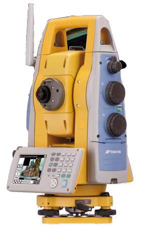
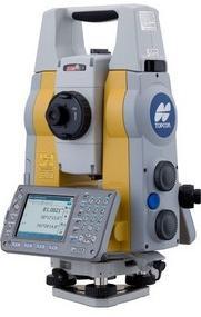
Topcon Robotic PS Series
PS Series
Advanced Design with Superior Technology
The PS is a professional grade robotic total station. This new advanced design provides an onboard data collection interface, exclusive LongLink communication, and an incredibly powerful EDM.
You can work directly on the bright, color touchscreen or with the alpha-numeric keyboard, to achieve higher levels of production with MAGNET Field onboard software. The PS total station can be used on a wide variety of applications. From building layout to earthwork volumes, and land surveying or control of your machines on site, the PS is the productive choice.
Topcons PS Series of robotic total stations is for the professional who is looking for a one-man solution for even the most challenging job site situation. This rugged, waterproof and dustproof total station series has the revolutionary TSshield advanced security and maintenance system, exclusive LongLink communications module, and the RC-5 integrated remote system.
Features:
New TSshield Advanced Security and Maintenance
PowerTrac Tracking
Fast and Powerful EDM
Exclusive LongLink Communications
Advanced Angle Accuracy
Rugged, Waterproof and Dustproof Design
Specifications
Telescope
Resolving power 2.5
Magnification 30x
Angle Measurement
Min. Resolution/Accuracy
PS-101 1”
PS-103 3”
PS-105 Not available in North America
Tilt Angle Compensation
Compensation Dual-axis compensator
Range ±6’
Distance Measurement
Prism EDM Range 6,000m
Prism EDM Accuracy 1.5mm+2ppm
Non-Prism Range 1,000m
Non-Prism Accuracy 2mm+2ppm (0.3-200m)
Measuring Time Fine: 0.9 sec
Rapid: 0.6 sec
Tracking: 0.4 sec
Communications
LongLink rover communication
USB 2.0 Slot (Host + Slave)
RS-232C Serial
General
Display Color Touch TFT 240 x 320 QVGA Display
Keyboard 25 keys with illuminator
Battery Operation Up to 4 hours
Dust/Water Protection IP65
Wireless Connection Bluetooth® Class 1
Operating Temperature -20°C to +50°C (-4°F to +122°F)
$
8,789.00
